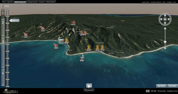
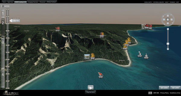
| The site shows visitors what happened at Gallipoli, moment-by-moment from the early hours of the morning, during the landing and as fighting commenced. You can access animated scenes, videos of interviews with soldiers and officers, archival images, photos and detailed information on weaponry and most important, 3D terrain data for all events, linked to the time of day. The result is feeling as though you had been at Gallipoli yourself.
Authentic Histor
The budget as well as the timeframe was limited, and this was Sam Doust’s first experience building an interactive website. The initial concept meetings established two goals - improving on existing capabilities for using interactive techniques to explore 3D data, and expressing the importance of terrain in the outcome of the Gallipoli battle. Help with authentic historical research came from many sources, in particular the Department of Veterans' Affairs, Macquarie University’s Modern History department, the Turkish General Staff Archives and the Australian War Memorial.
The most critical, however, was the geographical elevation data from the Digital Innovation Unit, University of Sydney, showing Gallipoli as it was in 1916 before urban development and infrastructure had changed its profile. This data is stored in their content management system, Heurist Reference Database, which integrates and sets up relationships between data assets, expresses these in XML and allowed Sam to import them into the ABC system as a basis for content and looks. The University’s Archaeology Department supplied GIS data for the terrain’s topography.
Getting Armed
Adobe Flash 10, new at the time the team started planning and able to support 3d animation, made the project seem more feasible. Senior Flash Developer Robert Stewart compiled a bridging program to use Flash 10 as their 3D animation environment. The terrain-based theme was maintained, but they found they had so much information, ranging from military strategy to the soldiers’ personal stories, that Sam Doust decided confining it to the first day, moment by moment, introduced to users through the Guided Tour, was the only way to get through it and meet the deadline.
Harvey Broadbent, an authority on the Gallipoli campaign, supervised the collection of information, strategy and historic detail on the day to ensure accuracy and impartiality for both sides. His in-depth understanding allowed the team to plot the course of events, movement of people and connections between them, across the terrain.
Sam took on the role of producer, editor, director and script developer armed with the full Adobe CS4 Suite and Flash 10, with the Flex web application framework, as his 3D environment. Google Earth, although only containing modern geographical data, was used as a development tool to integrate the latitude/longitude data. His team exported KML files containing coordinates to Google Earth to locate the specific events they wanted to place on the site.
3D Animation
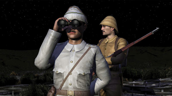
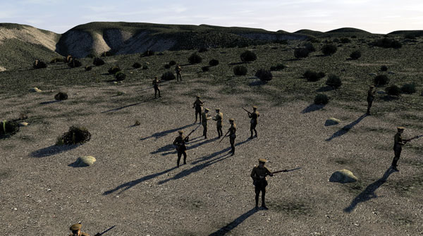
Because the project’s budget wouldn’t allow for moving animation, Plastic Wax, generously providing their talents at low cost, produced the static 3D characters, trenches, structures, boats, weapons for the 3D animation from Sam’s storyboards and research documents, photos and illustrations, using Maya. The ABC team then took over with Cinema 4D to create the 3D camera, lighting and rendering for diorama-like sequences taking place during the day.
Consequently, camera motion, changes in lighting to reflect time of day and light sources such as explosions, artistic rendering and all-important sound track provide the drama and action for the site’s animation. The critical work of sound designer, composer and mixer Roberto Salvatore integrated narration by actress Lucy Bell, diaries and letters read by actors Hugo Weaving, Quentin McDermott, Vecihi Ba?arin and Yusuf Nidai, vocal and various other sound effects – with the images, animation and video clips. www.editshare.com
|